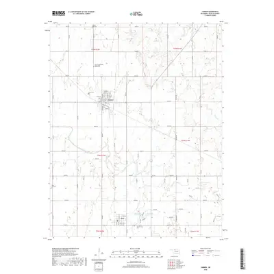
2018 Map of Carmen
USGS Topo · Published 2018About this map
Carmen and Aline anchor this Alfalfa County landscape, where the prairie grid is softened by the meandering course of Eagle Chief Cr. The town of Carmen is meticulously detailed, showing a street plan from Linden St down to Cherry St, while the southern settlement of Aline centers on Main St and Grand Ave. This map is particularly notable for its genealogical value, marking several fraternal and community burial grounds including the Carmen Independent Order of Odd Fellows Cem, the Eastern Star Cem, and Solf Cem. The hydrology is defined by the Big Timber Lakes West and Big Timber Lakes East, along with seasonal drainage from Spring Cr and W Clay Cr. The extensive section-line road network, such as E0300 Rd, illustrates the enduring agricultural structure of Oklahoma's northwestern plains.
Find a feature on this map
44 named features on this map. Tap any name to fly to it.
Don’t see what you’re looking for? This feature index may not catch every label — zoom into the map to look around manually.
Map Details
Editions of this 2018 Carmen Map
This is the sole edition of this map. No revisions or reprints were ever made.
Other maps of this area

1955 · Woodward
USGS Topo · 1:250,000

1958 · Woodward
USGS Topo · 1:250,000

1968 · Carmen
USGS Topo · 1:24,000

1969 · Dacoma
USGS Topo · 1:24,000

1969 · Lambert
USGS Topo · 1:24,000

1969 · Fairview NE
USGS Topo · 1:24,000

1969 · Helena
USGS Topo · 1:24,000

1969 · Cleo Springs
USGS Topo · 1:24,000

1969 · Glass Mountains NE
USGS Topo · 1:24,000
1969 · Dacoma SE
USGS Topo · 1:24,000