
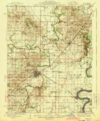
1943 Map of Carmi
USGS Topo · Published 1943About this map
Carmi serves as the focal point of this Southern Illinois survey, situated at the junction where the Little Wabash River meets the New York Central and Louisville and Nashville railroads. The landscape is defined by the winding course of the Little Wabash, which creates the distinctive Bumblebee Bend and is crossed by historical structures like Sigler Bridge and Winters Bridge. To the east, the Wabash River forms the state boundary, featuring The Rapids near the settlement of Rising Sun.
Find a feature on this map
92 named features on this map. Tap any name to fly to it.
Don’t see what you’re looking for? This feature index may not catch every label — zoom into the map to look around manually.
Map Details
Editions of this 1943 Carmi Map
2 editions found
Other maps of this area

1903 · New Harmony
USGS Topo · 1:62,500

1903 · Patoka
USGS Topo · 1:125,000

1904 · Mount Carmel
USGS Topo · 1:62,500

1905 · Eldorado
USGS Topo · 1:62,500

1905 · New Haven
USGS Topo · 1:62,500

1906 · New Haven
USGS Topo · 1:62,500

1906 · Eldorado
USGS Topo · 1:62,500

1917 · Uniontown
USGS Topo · 1:62,500

1938 · New Harmony
USGS Topo · 1:62,500

1940 · Carmi
USGS Topo · 1:62,500