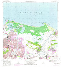
1969 Map of Carolina
USGS Topo · Published 1982About this map
Bosque Estatal de Piñones and the expansive Laguna de Piñones dominate the northern shoreline of this coastal landscape, illustrating the proximity of protected wetlands to rapidly growing urban centers. This 1969 survey, with revisions from 1982, documents the significant suburban expansion of Carolina and surrounding barrios such as Sabana Llana Norte and Hoyo Mulas. The urbanization is particularly evident in the development of Sabana Gardens and Villa Fontana, while the western edge is anchored by the Aeropuerto Internacional de Isla Verde. Transport and recreation are central to the area's character, shown through the Ferrocarril de Puerto Rico corridor and the Hipódromo El Comandante. Along the coast, the transition from developed sectors to more traditional areas like Piñones and the sandy stretch of Playa de las Tres Palmitas reflects the island's diverse land use during this era.
Find a feature on this map
86 named features on this map. Tap any name to fly to it.
Don’t see what you’re looking for? This feature index may not catch every label — zoom into the map to look around manually.
Map Details
Editions of this 1969 Carolina Map
3 editions found
Other maps of this area

1940 · Carolina
USGS Topo · 1:30,000

1941 · San Juan
USGS Topo · 1:30,000

1941 · Rio Grande
USGS Topo · 1:30,000

1941 · Carolina
USGS Topo · 1:30,000

1945 · El Yunque
USGS Topo · 1:30,000

1946 · El Yunque
USGS Topo · 1:30,000

1946 · Aguas Buenas
USGS Topo · 1:30,000

1946 · Gurabo
USGS Topo · 1:30,000

1947 · Carolina
USGS Topo · 1:30,000

1947 · Gurabo NE
USGS Topo · 1:10,000