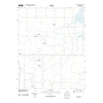
2010 Map of Carpenter
USGS Topo · Published 2010About this map
Carpenter serves as the primary settlement hub in this region of Roger Mills County, situated within a landscape defined by an extensive water management network. The northeastern corner is dominated by the Foss Reservoir and the Washita River, while the surrounding terrain is etched by a series of engineered flood control structures. These include numerous sites such as Panther Creek Watershed Site 1 Dam and Whiteshield Creek Site 5 Dam, which regulate the flow of Panther Creek and its tributaries. For those researching local family history, the map identifies the Thompson Cemetery and the adjacent Thompson Pixlee Cemetery in the southern portion of the quadrangle. The gridded road system, featuring routes like Pipeline Rd, provides a clear view of the rural property divisions and infrastructure supporting this Oklahoma agricultural community.
Find a feature on this map
32 named features on this map. Tap any name to fly to it.
Don’t see what you’re looking for? This feature index may not catch every label — zoom into the map to look around manually.
Map Details
Editions of this 2010 Carpenter Map
This is the sole edition of this map. No revisions or reprints were ever made.
Other maps of this area

1955 · Clinton
USGS Topo · 1:250,000

1957 · Clinton
USGS Topo · 1:250,000

1957 · Butler
USGS Topo · 1:62,500

1957 · Dill City
USGS Topo · 1:62,500

1960 · Hammon
USGS Topo · 1:62,500

1961 · Elk City
USGS Topo · 1:62,500

1976 · Butler NW
USGS Topo · 1:24,000

1976 · Butler SW
USGS Topo · 1:24,000

1976 · Dill City NE
USGS Topo · 1:24,000
1983 · Foss Dam
USGS Topo · 1:24,000