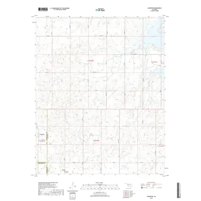
2018 Map of Carpenter
USGS Topo · Published 2018About this map
Carpenter sits at the junction of Roger Mills, Beckham, and Custer counties in this western Oklahoma landscape. The map captures a region defined by agricultural sections and a complex network of seasonal drainage, most notably the upper reaches of Foss Reservoir in the northeast. Water management and local history are central to this terrain, as seen in the various branches of Panther Cr, Little Panther Cr, and Soldier Cr that cut through the rolling land. For those researching local families, the Thompson Pixlee Cem serves as a significant genealogical marker near the southern boundary. The presence of Pipeline Rd and a strict grid of section roads like E1040 Rd reflects the modern infrastructure laid over this rural territory, where natural topography still dictates the placement of homes and farmsteads.
Find a feature on this map
24 named features on this map. Tap any name to fly to it.
Don’t see what you’re looking for? This feature index may not catch every label — zoom into the map to look around manually.
Map Details
Editions of this 2018 Carpenter Map
This is the sole edition of this map. No revisions or reprints were ever made.
Other maps of this area

1955 · Clinton
USGS Topo · 1:250,000

1957 · Clinton
USGS Topo · 1:250,000

1957 · Butler
USGS Topo · 1:62,500

1957 · Dill City
USGS Topo · 1:62,500

1960 · Hammon
USGS Topo · 1:62,500

1961 · Elk City
USGS Topo · 1:62,500

1976 · Butler NW
USGS Topo · 1:24,000

1976 · Butler SW
USGS Topo · 1:24,000

1976 · Dill City NE
USGS Topo · 1:24,000
1983 · Foss Dam
USGS Topo · 1:24,000