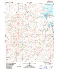
1987 Map of Carpenter
USGS Topo · Published 1987About this map
The boundary lines of Custer, Roger Mills, and Beckham counties intersect in this western Oklahoma landscape, characterized by the expansive waters of Foss Reservoir and the Washita National Wildlife Refuge. The map reveals a region defined by its rural infrastructure and energy extraction, with numerous labels for Gas Wells and Drill Holes scattered across the undulating terrain. Local life centers on small settlements and landmarks like Carpenter and the Colter Ch, while the Thompson Pixlee Cem near Thompson Pixlee provides a focal point for genealogical research in the southwestern portion of the quadrangle.
Find a feature on this map
19 named features on this map. Tap any name to fly to it.
Don’t see what you’re looking for? This feature index may not catch every label — zoom into the map to look around manually.
Map Details
Editions of this 1987 Carpenter Map
This is the sole edition of this map. No revisions or reprints were ever made.
Other maps of this area

1955 · Clinton
USGS Topo · 1:250,000

1957 · Clinton
USGS Topo · 1:250,000

1957 · Butler
USGS Topo · 1:62,500

1957 · Dill City
USGS Topo · 1:62,500

1960 · Hammon
USGS Topo · 1:62,500

1961 · Elk City
USGS Topo · 1:62,500

1976 · Butler NW
USGS Topo · 1:24,000

1976 · Butler SW
USGS Topo · 1:24,000

1976 · Dill City NE
USGS Topo · 1:24,000
1983 · Foss Dam
USGS Topo · 1:24,000