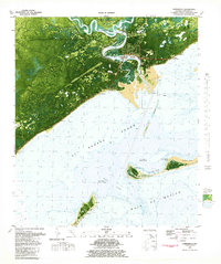
1981 Map of Carrabelle
USGS Topo · Published 1982About this map
The town of Carrabelle stands at the confluence of the Carrabelle River and St George Sound in this early 1980s orthophotomap. The landscape is defined by the transition from the dense, saturated timberlands of Tates Hell and Hell Swamp to the maritime activity of the Gulf coast. Evidence of the region’s mid-century strategic and industrial role is visible through the U S Air Force Tracking Station, the Carrabelle Flight Strip, and the Carrabelle Lookout Tower. Near the coast, landforms like Timber Island and Davis Island guard the river mouth, while the local education and community center is marked by the Carrabelle High Sch. The map also captures several smaller settlements and family-named landmarks, including Yent Place and Warrens Bluff, along the winding path of the Crooked River.
Find a feature on this map
42 named features on this map. Tap any name to fly to it.
Don’t see what you’re looking for? This feature index may not catch every label — zoom into the map to look around manually.
Map Details
Editions of this 1981 Carrabelle Map
4 editions found
Other maps of this area

1943 · Dog Island
USGS Topo · 1:31,680

1943 · Carrabelle
USGS Topo · 1:24,000

1944 · Pickett Bay
USGS Topo · 1:31,680

1944 · Carrabelle
USGS Topo · 1:31,680

1944 · Green Point
USGS Topo · 1:31,680

1944 · Sugar Hill
USGS Topo · 1:31,680

1945 · Tates Hell Swamp
USGS Topo · 1:31,680

1945 · Mc Intyre
USGS Topo · 1:31,680

1945 · Sugar Hill
USGS Topo · 1:31,680

1945 · Pickett Bay
USGS Topo · 1:31,680