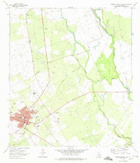
1972 Map of Carrizo Springs East
USGS Topo · Published 1975About this map
Carrizo Springs serves as the regional hub in this 1970s landscape, where the agricultural and industrial character of Dimmit County is clearly defined. The western edge of the map is dominated by the town's grid, featuring civic landmarks like the Jr High Sch, a Cem, and the County Airport. Significant industrial infrastructure is present, including a Refinery and the Missouri Pacific railroad line, which facilitated the movement of goods through this brush country region.
Find a feature on this map
29 named features on this map. Tap any name to fly to it.
Don’t see what you’re looking for? This feature index may not catch every label — zoom into the map to look around manually.
Map Details
Editions of this 1972 Carrizo Springs East Map
This is the sole edition of this map. No revisions or reprints were ever made.
Other maps of this area

1929 · Cotulla
USGS Topo · 1:125,000

1932 · Valley Wells
USGS Topo · 1:62,500

1939 · Carrizo Springs
USGS Topo · 1:62,500

1939 · Big Wells
USGS Topo · 1:62,500

1940 · Asherton
USGS Topo · 1:62,500

1940 · Catarina
USGS Topo · 1:62,500

1953 · Crystal City
USGS Topo · 1:250,000

1955 · Crystal City
USGS Topo · 1:250,000

1961 · Crystal City
USGS Topo · 1:250,000

1968 · Crystal City
USGS Topo · 1:250,000