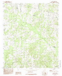
1984 Map of Carroll
USGS Topo · Published 1984About this map
The winding Neches River forms a jagged boundary between Van Zandt and Smith Counties in this mid-1980s Texas landscape. The terrain is defined by a dense network of tributaries including Big Sandy Creek, Rattlesnake Creek, and Prairie Creek, which drain toward the river through an area primarily shaped by rural settlements and local industry. Small communities like Carroll and Horsley serve as focal points for the surrounding countryside, while the presence of a Gravel Pit indicates the extraction of local resources. Near the southern edge of the sheet, the Edom Corporate Bdy and the community of Midway mark the transition toward more concentrated township boundaries. Water features such as Butler Lake and Shiloh Lake dot the map, highlighting the reliance on local catchments in this part of East Texas.
Find a feature on this map
22 named features on this map. Tap any name to fly to it.
Don’t see what you’re looking for? This feature index may not catch every label — zoom into the map to look around manually.
Map Details
Editions of this 1984 Carroll Map
This is the sole edition of this map. No revisions or reprints were ever made.
Other maps of this area

1948 · Tyler
USGS Topo · 1:62,500

1948 · Brownsboro
USGS Topo · 1:62,500

1949 · Tyler
USGS Topo · 1:62,500

1949 · Brownsboro
USGS Topo · 1:62,500

1956 · Tyler
USGS Topo · 1:250,000

1959 · Van
USGS Topo · 1:24,000

1959 · Van Lake
USGS Topo · 1:24,000

1959 · Grand Saline
USGS Topo · 1:62,500

1960 · Lindale
USGS Topo · 1:24,000

1966 · Chandler
USGS Topo · 1:24,000