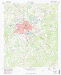
1973 Map of Carrollton
USGS Topo · Published 1983About this map
Carrollton serves as the regional hub of Carroll County, anchored by the expanding campus of West Georgia College and a central district featuring the Courthouse, City Hall, and Hospital. The town's mid-century growth is evident in the residential sprawl along Sunset Blvd and West Ave, while the surrounding landscape maintains its rural character with family-named roads and landmarks. The Central of Georgia railroad cuts diagonally across the terrain, passing through the smaller settlement of Clem to the southeast.
Find a feature on this map
69 named features on this map. Tap any name to fly to it.
Don’t see what you’re looking for? This feature index may not catch every label — zoom into the map to look around manually.
Map Details
Editions of this 1973 Carrollton Map
3 editions found
Other maps of this area

1889 · Tallapoosa
USGS Topo · 1:125,000

1891 · Marietta
USGS Topo · 1:125,000

1892 · Tallapoosa
USGS Topo · 1:125,000

1895 · Marietta
USGS Topo · 1:125,000

1897 · Marietta
USGS Topo · 1:125,000

1897 · Tallapoosa
USGS Topo · 1:125,000

1899 · Wedowee
USGS Topo · 1:125,000

1901 · Marietta
USGS Topo · 1:125,000

1902 · Wedowee
USGS Topo · 1:125,000

1953 · Atlanta
USGS Topo · 1:250,000