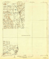
1931 Map of Carrollton
USGS Topo · Published 1938About this map
Carrollton and the surrounding North Texas landscape appear in the mid-1920s as a vital railroad junction north of Dallas. The map illustrates a dense network of competing rail lines, including the St Louis Southwestern and the Missouri Kansas and Texas, which intersected at Carrollton and nearby Trinity Mills. The Elm Fork Trinity River snakes through the center of the sheet, its meanders defining the agricultural and social boundaries of the era.
Find a feature on this map
41 named features on this map. Tap any name to fly to it.
Don’t see what you’re looking for? This feature index may not catch every label — zoom into the map to look around manually.
Map Details
Editions of this 1931 Carrollton Map
3 editions found
Other maps of this area

1891 · Dallas
USGS Topo · 1:125,000

1893 · Dallas
USGS Topo · 1:125,000

1894 · Fort Worth
USGS Topo · 1:125,000

1925 · Mc Kinney 3-c
USGS Topo · 1:48,000

1925 · Dallas 2-b
USGS Topo · 1:48,000

1929 · Frisco
USGS Topo · 1:62,500

1929 · McKinney
USGS Topo · 1:62,500

1931 · Carrollton
USGS Topo · 1:62,500

1931 · Grapevine
USGS Topo · 1:62,500

1954 · Dallas
USGS Topo · 1:250,000