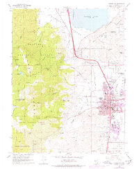
1968 Map of Carson City
USGS Topo · Published 1976About this map
Carson City serves as the focal point of this 1968 survey, showing the Nevada state capital just before significant late-20th-century expansion. The urban grid is clearly defined by historical thoroughfares like King St and 5th St, while the city's civic identity is anchored by the Gov Mansion, the state Museum, and the Armory. Purple photorevision tints from 1974 indicate the emerging residential growth patterns pushing toward the Virginia Range and the Carson Indian Colony to the south.
Find a feature on this map
71 named features on this map. Tap any name to fly to it.
Don’t see what you’re looking for? This feature index may not catch every label — zoom into the map to look around manually.
Map Details
Editions of this 1968 Carson City Map
3 editions found
Other maps of this area

1891 · Carson
USGS Topo · 1:125,000

1893 · Carson
USGS Topo · 1:125,000

1950 · Virginia City
USGS Topo · 1:62,500

1950 · Mt. Rose
USGS Topo · 1:62,500

1952 · Mt. Rose
USGS Topo · 1:62,500

1952 · Virginia City
USGS Topo · 1:62,500

1955 · Marlette Lake
USGS Topo · 1:24,000

1955 · Glenbrook
USGS Topo · 1:24,000

1956 · Dayton
USGS Topo · 1:62,500

1956 · Carson City
USGS Topo · 1:62,500