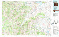
1980 Map of Carter Mountain
USGS Topo · Published 1982About this map
Shoshone National Forest and Teton National Forest encompass the majority of this high-elevation landscape in northwest Wyoming. The drainage systems of the North Fork Shoshone River and South Fork Shoshone River converge toward the Buffalo Bill Reservoir, highlighting the area's role in regional water management. Civil engineering and irrigation efforts are visible through the Lakeview Ditch, which draws from these alpine sources to serve lower-lying terrain.
Find a feature on this map
44 named features on this map. Tap any name to fly to it.
Don’t see what you’re looking for? This feature index may not catch every label — zoom into the map to look around manually.
Map Details
Editions of this 1980 Carter Mountain Map
3 editions found

Other maps of this area

1885 · Lake
USGS Topo · 1:125,000

1886 · Canyon
USGS Topo · 1:125,000

1893 · Ishawooa
USGS Topo · 1:125,000

1895 · Ishawooa
USGS Topo · 1:125,000

1895 · Canyon
USGS Topo · 1:125,000

1895 · Lake
USGS Topo · 1:125,000

1896 · Lake
USGS Topo · 1:125,000

1896 · Canyon
USGS Topo · 1:125,000

1896 · Crandall Creek
USGS Topo · 1:125,000

1899 · Crandall
USGS Topo · 1:125,000