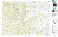
1980 Map of Carter Mountain
USGS Topo · Published 1982About this map
Shoshone National Forest and Teton National Forest dominate this high-elevation landscape, where the North Fork Shoshone River flows into the expansive Buffalo Bill Reservoir. The 1980 map data illustrates the transition from the high ridges of Wapiti Ridge and Carter Mountain down to the drainage basins of the Greybull River and Wood River. Local landmarks such as the Ranger Sta and various Gaging Sta placements indicate the managed nature of these protected lands. Near the eastern edge, an Oil Field and Gravel Pit suggest localized industrial activity amidst the terrain. The presence of settlements like Wapiti and Irma near the reservoir highlights the primary corridors of travel along U S 14 16 20, providing a record of the region's human geography before modern development expanded around the reservoir's shores.
Find a feature on this map
40 named features on this map. Tap any name to fly to it.
Don’t see what you’re looking for? This feature index may not catch every label — zoom into the map to look around manually.
Map Details
Editions of this 1980 Carter Mountain Map
3 editions found

Other maps of this area

1885 · Lake
USGS Topo · 1:125,000

1886 · Canyon
USGS Topo · 1:125,000

1893 · Ishawooa
USGS Topo · 1:125,000

1895 · Ishawooa
USGS Topo · 1:125,000

1895 · Canyon
USGS Topo · 1:125,000

1895 · Lake
USGS Topo · 1:125,000

1896 · Lake
USGS Topo · 1:125,000

1896 · Canyon
USGS Topo · 1:125,000

1896 · Crandall Creek
USGS Topo · 1:125,000

1899 · Crandall
USGS Topo · 1:125,000