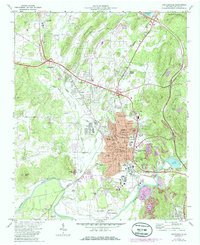
1972 Map of Cartersville
USGS Topo · Published 1986About this map
Etowah Mounds State Historic Site anchors the southern portion of this landscape, preserving ancient Indian Mounds along a bend in the Etowah River. The 1970s and early 1980s represent a period of industrial activity and suburban transition for the region, evidenced by the proximity of large Strip Mines and an Industrial Waste Pond to growing residential districts like Oakland Heights and Atco. Further north, the historic village of Cassville stands in contrast to the expanding infrastructure of Cartersville, where the Howell Memorial Hosp and Civic Center serve as modern community hubs. The presence of the Seaboard railroad line and various transport markers like Cartersville Airport and a Drive-in Theater illustrate a mid-century economy evolving around the intersection of river, rail, and road.
Find a feature on this map
76 named features on this map. Tap any name to fly to it.
Don’t see what you’re looking for? This feature index may not catch every label — zoom into the map to look around manually.
Map Details
Editions of this 1972 Cartersville Map
2 editions found
Other maps of this area

1890 · Cartersville
USGS Topo · 1:125,000

1891 · Cartersville
USGS Topo · 1:125,000

1896 · Cartersville
USGS Topo · 1:125,000

1906 · Stilesboro
USGS Topo · 1:62,500

1907 · Acworth
USGS Topo · 1:62,500

1908 · Stilesboro
USGS Topo · 1:62,500

1909 · Acworth
USGS Topo · 1:62,500

1941 · Adairsville
USGS Topo · 1:62,500

1944 · Adairsville
USGS Topo · 1:62,500

1947 · Waleska
USGS Topo · 1:62,500