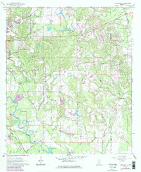
1964 Map of Carterville
USGS Topo · Published 1985About this map
The Leaf River winds through the southern reaches of this landscape, its banks dotted with named oxbows and inlets like Aldrich Lake and Owens Bluff Lake. The arrival of the Illinois Central Gulf Railroad near the Hattiesburg Municipal Airport signals the mid-century industrial expansion of the region. This 1964 survey captures a moment when rural communities like Carterville and Sunrise maintained their local identities through centralized landmarks such as the Sunrise Sch and various country parishes, including Mt Vernon Ch and Corinth Ch. The terrain is defined by a dense network of tributaries including Greens Creek and Reese Creek, while industrial activity is evidenced by multiple Gravel Pits and the Petal Waterworks, reflecting a landscape balancing natural water resources with suburban and logistical growth.
Find a feature on this map
58 named features on this map. Tap any name to fly to it.
Don’t see what you’re looking for? This feature index may not catch every label — zoom into the map to look around manually.
Map Details
Editions of this 1964 Carterville Map
5 editions found
Other maps of this area

1947 · New Augusta
USGS Topo · 1:62,500

1949 · New Augusta
USGS Topo · 1:62,500

1953 · Hattiesburg
USGS Topo · 1:250,000

1958 · Hattiesburg
USGS Topo · 1:250,000

1963 · Barrontown
USGS Topo · 1:24,000

1964 · Carterville
USGS Topo · 1:24,000

1964 · Ovett SE
USGS Topo · 1:24,000

1964 · Ovett
USGS Topo · 1:24,000

1964 · Hattiesburg
USGS Topo · 1:24,000

1965 · Dixie
USGS Topo · 1:24,000