
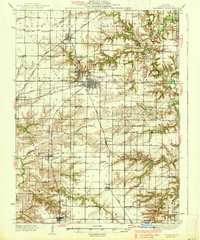
1937 Map of Carthage
USGS Topo · Published 1937About this map
Carthage serves as the hub of this Hancock County landscape, where the local rail network converges at the town's center. Three major lines, the Chicago Burlington and Quincy, the Wabash, and the Toledo Peoria and Western, connect the seat to outlying villages like Ferris, Bentley, and Elvaston. The surrounding townships are densely dotted with one-room schools, reflecting a vibrant rural community structure in the early 20th century. Notable local institutions include the County Farm just south of Carthage and numerous rural meeting places such as Middle Creek Ch. The terrain is shaped by the winding courses of Rock Creek, Middle Creek, and Bear Creek, which carve through the prairie to create the varied elevations shown in this mid-1930s survey.
Find a feature on this map
78 named features on this map. Tap any name to fly to it.
Don’t see what you’re looking for? This feature index may not catch every label — zoom into the map to look around manually.
Map Details
Editions of this 1937 Carthage Map
2 editions found
Other maps of this area

1913 · Colchester
USGS Topo · 1:62,500

1918 · La Harpe
USGS Topo · 1:62,500

1932 · Lomax
USGS Topo · 1:62,500

1933 · Carthage
USGS Topo · 1:62,500

1936 · Keokuk
USGS Topo · 1:62,500

1936 · Fort Madison
USGS Topo · 1:62,500

1937 · Lomax
USGS Topo · 1:62,500

1946 · Augusta
USGS Topo · 1:62,500

1946 · Mendon
USGS Topo · 1:62,500

1948 · Mendon
USGS Topo · 1:62,500