
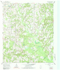
1960 Map of Cartwright
USGS Topo · Published 1962About this map
Big Sandy Creek and its many meandering tributaries, including Turkey Creek and Stout Creek, carve through this section of Wood County. The landscape is defined by small, dispersed rural settlements and local institutions that served the mid-century farming community. Small communities like Cartwright and Stout anchor the northern reaches, while Little Hope sits near the eastern edge. Local genealogy and social history are preserved in the locations of Shady Grove Ch, Ebenezer Ch, and the Lone Grove Sch, illustrating the dispersed nature of East Texas country life before significant modernization. The presence of named water features like Crones Pond, Long Lake, and Round Lake suggests a low-lying, well-watered terrain where drainage basins dictated the placement of roads like the Merigale-Paul Road and the early settlement patterns of family-named landmarks.
Find a feature on this map
37 named features on this map. Tap any name to fly to it.
Don’t see what you’re looking for? This feature index may not catch every label — zoom into the map to look around manually.
Map Details
Editions of this 1960 Cartwright Map
2 editions found
Other maps of this area

1956 · Tyler
USGS Topo · 1:250,000

1960 · Shady Grove
USGS Topo · 1:24,000

1960 · Hainesville
USGS Topo · 1:24,000

1960 · Winnsboro
USGS Topo · 1:24,000

1960 · Mineola
USGS Topo · 1:24,000

1960 · Newsome
USGS Topo · 1:24,000

1960 · Rhonesboro
USGS Topo · 1:24,000

1960 · Pleasant Grove
USGS Topo · 1:24,000

1960 · Quitman
USGS Topo · 1:24,000

1984 · Tyler
USGS Topo · 1:250,000