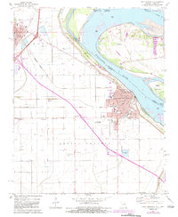
1971 Map of Caruthersville
USGS Topo · Published 1983About this map
The Mississippi River creates a sweeping boundary between Missouri and Tennessee in this early 1970s survey, updated with revised cultural features through 1983. The landscape is dominated by the river town of Caruthersville and the nearby junction at Hayti. This region, part of the Little Prairie, reveals a dense agricultural and transportation network where the Burlington Northern railroad lines intersect with newly constructed interstate interchanges.
Find a feature on this map
55 named features on this map. Tap any name to fly to it.
Don’t see what you’re looking for? This feature index may not catch every label — zoom into the map to look around manually.
Map Details
Editions of this 1971 Caruthersville Map
3 editions found
Other maps of this area

1939 · Portageville
USGS Topo · 1:62,500

1939 · Caruthersville
USGS Topo · 1:62,500

1940 · Pascola
USGS Topo · 1:62,500

1940 · Hayti
USGS Topo · 1:62,500

1951 · Caruthersville
USGS Topo · 1:62,500

1955 · Pascola
USGS Topo · 1:62,500

1955 · Hayti
USGS Topo · 1:62,500

1955 · Portageville
USGS Topo · 1:62,500

1956 · Dyersburg
USGS Topo · 1:250,000

1957 · Caruthersville
USGS Topo · 1:62,500