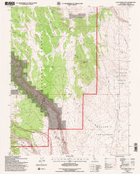
1994 Map of Casa Diablo Mtn.
USGS Topo · Published 1997About this map
The Owens River Gorge dominates this landscape, cutting a deep path through the Volcanic Tableland and revealing the region's complex geological history. In the mid-1990s, this area reflects a intersection of industrial utility and environmental preservation. Utility infrastructure is evident along the river's course, including a Powerhouse, Gaging Station, and multiple Surge Tank installations, while the eastern portion of the map is protected as the Fish Slough Area of Critical Environmental Concern.
Find a feature on this map
23 named features on this map. Tap any name to fly to it.
Don’t see what you’re looking for? This feature index may not catch every label — zoom into the map to look around manually.
Map Details
Editions of this 1994 Casa Diablo Mtn. Map
2 editions found
Other maps of this area

1912 · Mt. Goddard
USGS Topo · 1:125,000

1913 · Bishop
USGS Topo · 1:125,000

1914 · Mt. Morrison
USGS Topo · 1:125,000

1917 · White Mountain
USGS Topo · 1:125,000

1947 · Mariposa
USGS Topo · 1:250,000

1948 · Mariposa
USGS Topo · 1:250,000

1949 · Mt. Tom
USGS Topo · 1:62,500

1949 · Bishop
USGS Topo · 1:62,500

1951 · Mt. Tom
USGS Topo · 1:62,500

1951 · Bishop
USGS Topo · 1:62,500