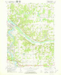
1978 Map of Cascade
USGS Topo · Published 1979About this map
The Grand River and Thornapple River converge near Ada, forming the central geography of this Kent County landscape in the late 1970s. This survey captures a period of suburban transition for the townships of Vergennes, Cascade, and Lowell, where traditional orchards and ஏராளமான Gravel Pits are interspersed with emerging residential street networks. The presence of the Covered Bridge at Ada and multiple small family or local burial grounds like Krum Cem and Wright Cem provides significant detail for genealogists and local historians. Rural infrastructure is well-documented, from the Somerville Landing Strip to the Chesapeake And Ohio River railroad line running through the river valley. Numerous neighborhood landmarks, including the Christian Sch and Thornapple Sch, anchor the settlements as they expanded along corridors like Cascade Road and Whitneyville Ave.
Find a feature on this map
42 named features on this map. Tap any name to fly to it.
Don’t see what you’re looking for? This feature index may not catch every label — zoom into the map to look around manually.
Map Details
Editions of this 1978 Cascade Map
2 editions found

Other maps of this area

1914 · Grand Rapids
USGS Topo · 1:62,500

1918 · Cedar Springs
USGS Topo · 1:62,500

1918 · Lowell
USGS Topo · 1:62,500

1943 · Cedar Springs
USGS Topo · 1:62,500

1943 · Grand Rapids
USGS Topo · 1:62,500

1943 · Lowell
USGS Topo · 1:62,500

1954 · Midland
USGS Topo · 1:250,000

1958 · Midland
USGS Topo · 1:250,000

1958 · Grand Rapids
USGS Topo · 1:250,000

1959 · Midland
USGS Topo · 1:250,000
Featured Places
- Cascade Charter Township, MI
- Ada Township, MI
- Lowell Charter Township, MI
- Vergennes Township, MI
- Cascade, Cascade Charter Township