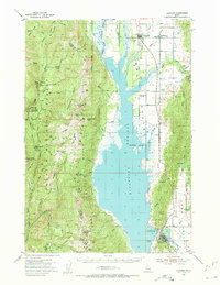
1954 Map of Cascade
USGS Topo · Published 1956About this map
The Cascade Reservoir dominates this mid-century landscape in Valley County, capturing the region as the artificial lake reached its full footprint. Established along the Union Pacific rail line, the town of Cascade serves as the southern anchor, complete with its nearby Cascade Park and a Gaging Station on the North Fork Payette River. Further north, the settlements of Donnelly, Roseberry, and Arling illustrate the rural distribution of the valley before further modernization. To the west, the topography rises sharply into the Payette National Forest, where resource extraction and forest management are evident at the Mica Mine near Mica Hill and the Corral Creek Guard Station. Significant for local historians, the map identifies small landmarks like Homer Cemetery and the Landing Field near Donnelly, alongside numerous mountain lookouts such as Indian Mtn Lookout.
Find a feature on this map
84 named features on this map. Tap any name to fly to it.
Don’t see what you’re looking for? This feature index may not catch every label — zoom into the map to look around manually.
Map Details
Editions of this 1954 Cascade Map
2 editions found
Other maps of this area

1894 · Squaw Creek
USGS Topo · 1:125,000

1909 · Garden Valley
USGS Topo · 1:125,000

1911 · Meadows
USGS Topo · 1:125,000

1953 · Smiths Ferry
USGS Topo · 1:62,500

1953 · Boiling Springs
USGS Topo · 1:62,500

1954 · Gold Fork
USGS Topo · 1:62,500

1954 · Council
USGS Topo · 1:62,500

1954 · New Meadows
USGS Topo · 1:62,500

1954 · Cascade
USGS Topo · 1:62,500

1955 · Baker
USGS Topo · 1:250,000