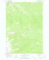
1963 Map of Casino Lakes
USGS Topo · Published 1977About this map
Salmon River headwaters and the upper reaches of the Sawtooth Valley dominate this mountain landscape during the early 1960s. The map illustrates a high-altitude wilderness defined by the intersection of Challis National Forest and Sawtooth National Forest. Significant water features like the cluster of Casino Lakes, Garland Lakes, and Rough Lake are tucked into the high ridges, accessible only by a primitive network of trails and jeep trails. Human activity is sparse but notable, with the Salmon River Campground providing a base for recreation near the river, while a small Mine and a Gravel Pit indicate local extraction. For aviation in the backcountry, the Rough Creek Airport serves as a remote landing strip along the drainage of Rough Creek, a vital piece of infrastructure for forest management and remote access during this era.
Find a feature on this map
30 named features on this map. Tap any name to fly to it.
Don’t see what you’re looking for? This feature index may not catch every label — zoom into the map to look around manually.
Map Details
Editions of this 1963 Casino Lakes Map
4 editions found
Other maps of this area

1919 · Custer
USGS Topo · 1:125,000

1922 · Custer
USGS Topo · 1:125,000

1957 · Challis
USGS Topo · 1:250,000

1960 · Challis
USGS Topo · 1:250,000

1963 · Challis
USGS Topo · 1:250,000

1963 · Mt Cramer
USGS Topo · 1:24,000

1963 · Stanley
USGS Topo · 1:24,000

1963 · Basin Butte
USGS Topo · 1:24,000

1963 · Casino Lakes
USGS Topo · 1:24,000
1963 · Obsidian
USGS Topo · 1:24,000