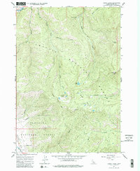
1963 Map of Casino Lakes
USGS Topo · Published 1984About this map
Challis National Forest and Sawtooth National Forest converge in this high-altitude landscape of central Idaho. The map centers on the high basins of Casino Lakes and Garland Lakes, where the drainage of Big Casino Creek and Rough Creek flow north toward the Salmon River. A high-country landing strip, Rough Creek Airport, sits perched above the deep valleys, indicating the specialized aviation required for access in this era. To the northwest, the Salmon River Campground marks the recreational corridor along the river, while a Mine and Gravel Pit suggest small-scale resource extraction. A network of Jeep Trails provides the primary means of traversal through the dense contour lines, passing landmarks like Lookout Mtn and Rough Lake. The boundary between the two national forests and the transition into the northern end of Sawtooth Valley characterize the southern portion of the survey.
Find a feature on this map
27 named features on this map. Tap any name to fly to it.
Don’t see what you’re looking for? This feature index may not catch every label — zoom into the map to look around manually.
Map Details
Editions of this 1963 Casino Lakes Map
4 editions found
Other maps of this area

1919 · Custer
USGS Topo · 1:125,000

1922 · Custer
USGS Topo · 1:125,000

1957 · Challis
USGS Topo · 1:250,000

1960 · Challis
USGS Topo · 1:250,000

1963 · Challis
USGS Topo · 1:250,000

1963 · Mt Cramer
USGS Topo · 1:24,000

1963 · Stanley
USGS Topo · 1:24,000

1963 · Basin Butte
USGS Topo · 1:24,000

1963 · Casino Lakes
USGS Topo · 1:24,000
1963 · Obsidian
USGS Topo · 1:24,000