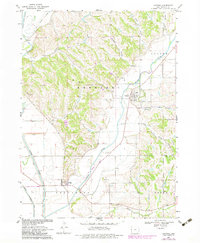
1969 Map of Castana
USGS Topo · Published 1983About this map
The Maple River and Little Sioux River valleys converge in this portion of Monona County, defining a landscape of agricultural lowlands protected by an extensive Levee system and the Harrison Ditch. The small settlements of Castana and Turin serve as local hubs, while the surrounding terrain is marked by prominent loess hills such as Durr Hill and Granger Hill.
Find a feature on this map
27 named features on this map. Tap any name to fly to it.
Don’t see what you’re looking for? This feature index may not catch every label — zoom into the map to look around manually.
Map Details
Editions of this 1969 Castana Map
2 editions found

Other maps of this area

1954 · Omaha
USGS Topo · 1:250,000

1954 · Fort Dodge
USGS Topo · 1:250,000

1955 · Sioux City
USGS Topo · 1:250,000

1955 · Fremont
USGS Topo · 1:250,000

1957 · Fremont
USGS Topo · 1:250,000

1957 · Omaha
USGS Topo · 1:250,000

1957 · Fort Dodge
USGS Topo · 1:250,000

1958 · Sioux City
USGS Topo · 1:250,000

1958 · Omaha
USGS Topo · 1:250,000

1958 · Fremont
USGS Topo · 1:250,000