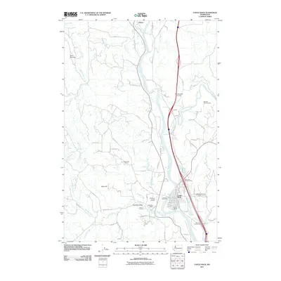
2011 Map of Castle Rock
USGS Topo · Published 2011About this map
Castle Rock serves as the primary hub along the Cowlitz River, where the landscape transitions from the broad Arkansas Valley to the rising elevations of Bebe Mountain and Ogden Hill. This corridor is defined by its deep connection to the river and the arterial Old Pacific Highway, which connects the valley settlements of Olequa and Gardner. The presence of the Castle Rock Fairgrounds and the Barnes Forest Corridor reflects a mix of civic gathering spaces and preserved natural timberlands that characterize this portion of Cowlitz County.
Find a feature on this map
84 named features on this map. Tap any name to fly to it.
Don’t see what you’re looking for? This feature index may not catch every label — zoom into the map to look around manually.
Map Details
Editions of this 2011 Castle Rock Map
This is the sole edition of this map. No revisions or reprints were ever made.
Other maps of this area

1919 · Mayger
USGS Topo · 1:62,500

1921 · Kalama
USGS Topo · 1:62,500

1941 · Olequa
USGS Topo · 1:62,500

1941 · Clatskanie
USGS Topo · 1:62,500

1952 · Clatskanie
USGS Topo · 1:62,500

1953 · Hoquiam
USGS Topo · 1:250,000

1953 · Castle Rock
USGS Topo · 1:62,500

1953 · Mt. Brynion
USGS Topo · 1:24,000

1953 · Ryderwood
USGS Topo · 1:62,500
1953 · Kelso
USGS Topo · 1:24,000