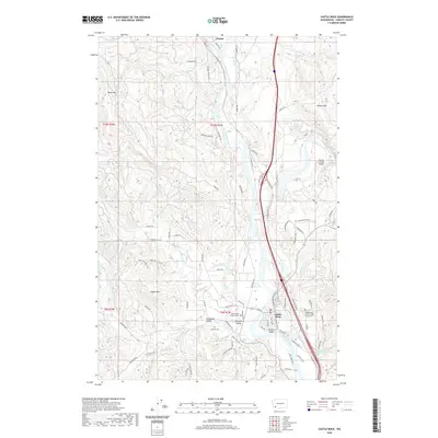
2020 Map of Castle Rock
USGS Topo · Published 2020About this map
Cowlitz River drainage patterns define the geography of this Cowlitz County corridor, where the river meets the Toutle River just north of Castle Rock. The landscape is a mix of river bottomlands and rising timbered heights like Bebe Mtn and Wilkes Hills. Local family history is well-preserved through several established burial grounds, including the Whittle and Hubbard Cem, the Jackson Cem, and the Independent Order of Odd Fellows Cem. Rural life is centered in the Arkansas Valley and Delameter Valley, connected by historical routes such as the Old Pacific Hwy and Westside Hwy. North of the main settlement, the community of Olequa sits near the confluence of Olequa Creek and the river, reflecting the area's long-standing reliance on these waterways for transport and irrigation.
Find a feature on this map
95 named features on this map. Tap any name to fly to it.
Don’t see what you’re looking for? This feature index may not catch every label — zoom into the map to look around manually.
Map Details
Editions of this 2020 Castle Rock Map
This is the sole edition of this map. No revisions or reprints were ever made.
Other maps of this area

1919 · Mayger
USGS Topo · 1:62,500

1921 · Kalama
USGS Topo · 1:62,500

1941 · Olequa
USGS Topo · 1:62,500

1941 · Clatskanie
USGS Topo · 1:62,500

1952 · Clatskanie
USGS Topo · 1:62,500

1953 · Hoquiam
USGS Topo · 1:250,000

1953 · Castle Rock
USGS Topo · 1:62,500

1953 · Mt. Brynion
USGS Topo · 1:24,000

1953 · Ryderwood
USGS Topo · 1:62,500
1953 · Kelso
USGS Topo · 1:24,000