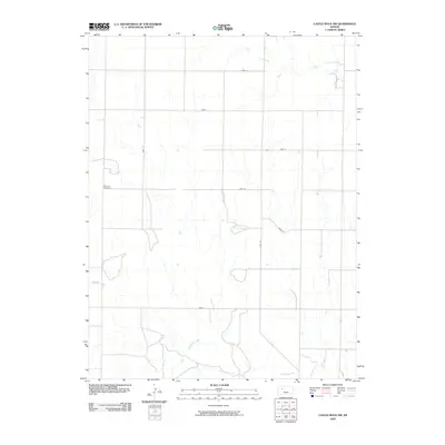
2009 Map of Castle Rock NW
USGS Topo · Published 2009About this map
Red Top Cemetery sits as a solitary cultural landmark in this section of Gove County, where the High Plains landscape is defined by a rigid grid of rural roads and meandering drainage systems. The survey area is organized by the Gove County road network, including thoroughfares such as Gove 74, Gove 80, and Gove U, which carve the prairie into predictable sections for ranching and agriculture. The drainage of the land is dictated by the eastward-flowing waters of Big Creek in the north and the complex tributaries of Hackberry Creek in the south. These waterways are seasonal in nature, yet they create the only significant breaks in the flat, surveyed geometry of the region. The map highlights a typical late-twentieth-century Kansas rural structure, where human presence is sparse and focused on the intersections of named county lines.
Find a feature on this map
11 named features on this map. Tap any name to fly to it.
Don’t see what you’re looking for? This feature index may not catch every label — zoom into the map to look around manually.
Map Details
Editions of this 2009 Castle Rock NW Map
This is the sole edition of this map. No revisions or reprints were ever made.
Other maps of this area

1954 · Goodland
USGS Topo · 1:250,000

1955 · Scott City
USGS Topo · 1:250,000

1956 · Goodland
USGS Topo · 1:250,000

1957 · Goodland
USGS Topo · 1:250,000

1958 · Scott City
USGS Topo · 1:250,000

1972 · Gove NE
USGS Topo · 1:24,000

1972 · Castle Rock NW
USGS Topo · 1:24,000
1972 · Castle Rock NE
USGS Topo · 1:24,000

1974 · Gove SE
USGS Topo · 1:24,000

1974 · Castle Rock
USGS Topo · 1:24,000