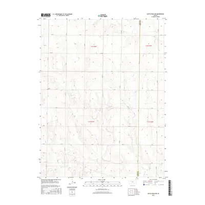
2015 Map of Castle Rock NW
USGS Topo · Published 2015About this map
Red Top Cem stands as a distinct landmark in this high plains landscape of western Kansas, situated near the western edge of the survey area. The terrain is defined by the drainage networks of Big Creek in the north and Hackberry Creek in the south, which carve through the prairie on their way toward the Gove County and Trego County line. This 2015 edition captures a landscape organized by an exacting grid of section lines and county roads, such as Co Rd 74 and Gove R. The interplay between the natural meandering of the creeks and the rigid township and range system—specifically sections of t12s r26w and t13s r25w—illustrates the modern agricultural and administrative character of this rural region.
Find a feature on this map
32 named features on this map. Tap any name to fly to it.
Don’t see what you’re looking for? This feature index may not catch every label — zoom into the map to look around manually.
Map Details
Editions of this 2015 Castle Rock NW Map
This is the sole edition of this map. No revisions or reprints were ever made.
Other maps of this area

1954 · Goodland
USGS Topo · 1:250,000

1955 · Scott City
USGS Topo · 1:250,000

1956 · Goodland
USGS Topo · 1:250,000

1957 · Goodland
USGS Topo · 1:250,000

1958 · Scott City
USGS Topo · 1:250,000

1972 · Gove NE
USGS Topo · 1:24,000

1972 · Castle Rock NW
USGS Topo · 1:24,000
1972 · Castle Rock NE
USGS Topo · 1:24,000

1974 · Gove SE
USGS Topo · 1:24,000

1974 · Castle Rock
USGS Topo · 1:24,000