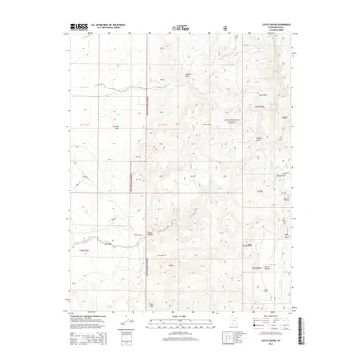
2014 Map of Casto Canyon
USGS Topo · Published 2014About this map
Dixie National Forest dominates this section of Garfield County, where the high desert landscape is defined by a network of drainage systems and family-named landmarks. The terrain is deeply incised by canyons and draws, most notably the legendary Butch Cassidy Draw and the winding Casto Canyon. Water sources are critical points on this map, from the high-elevation Birch Spring to the clustered Casto Springs at the base of the canyon walls. These springs often provided the only reliable water for livestock and early travelers navigating through the complex topography of the Clark Bench and Mud Spring Bench. The transition between flat-topped mesas and deep washes like Peterson Wash illustrates a classic erosion-shaped environment where remote routes like Limekiln Rd and Dump Casto provide the primary access to this interior wilderness.
Find a feature on this map
32 named features on this map. Tap any name to fly to it.
Don’t see what you’re looking for? This feature index may not catch every label — zoom into the map to look around manually.
Map Details
Editions of this 2014 Casto Canyon Map
This is the sole edition of this map. No revisions or reprints were ever made.
Other maps of this area

1886 · Kanab
USGS Topo · 1:250,000

1953 · Cedar City
USGS Topo · 1:250,000

1958 · Cedar City
USGS Topo · 1:250,000

1962 · Cedar City
USGS Topo · 1:250,000

1966 · Wilson Peak
USGS Topo · 1:24,000
1966 · Bryce Canyon
USGS Topo · 1:24,000

1966 · Hatch
USGS Topo · 1:24,000

1966 · Panguitch NW
USGS Topo · 1:24,000
1971 · Flake Mtn West
USGS Topo · 1:24,000
1971 · Adams Head
USGS Topo · 1:24,000