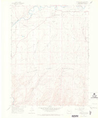
1966 Map of Castor Gulch
USGS Topo · Published 1969About this map
The Yampa River winds across the northern reaches of this Colorado landscape, defining a wide valley that includes Big Bottom and the Craig Corporate Boundary. On the southern outskirts of the regional hub, the residential area of Craig South Highlands sits near the Municipal Airport and a local Golf Course. This mid-1960s survey documents a transition from the river-fed plains to the higher elevations of the Williams Fork Mountains in the south, where the terrain is carved by numerous drainage systems like Castor Gulch and Pyeatt Gulch.
Find a feature on this map
31 named features on this map. Tap any name to fly to it.
Don’t see what you’re looking for? This feature index may not catch every label — zoom into the map to look around manually.
Map Details
Editions of this 1966 Castor Gulch Map
3 editions found
Other maps of this area

1910 · Danforth Hills
USGS Topo · 1:125,000

1915 · Monument Butte
USGS Topo · 1:62,500

1916 · Craig
USGS Topo · 1:125,000

1916 · Daton Peak
USGS Topo · 1:62,500

1920 · Daton Peak
USGS Topo · 1:62,500

1923 · Elkhead Creek
USGS Topo · 1:62,500

1924 · Elkhead Creek
USGS Topo · 1:62,500

1954 · Craig
USGS Topo · 1:250,000

1957 · Craig
USGS Topo · 1:250,000

1958 · Craig
USGS Topo · 1:250,000