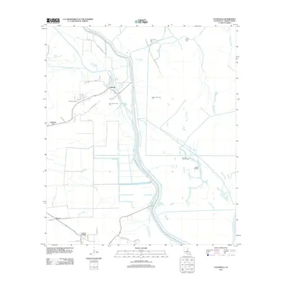
2012 Map of Catahoula
USGS Topo · Published 2012About this map
The settlement of Catahoula serves as the focal point of this Saint Martin Parish landscape, situated near the western edge of the Atchafalaya Basin. The map details a complex network of bayous and man-made infrastructure, defined by the Catahoula Levee Rd, Henderson Levee Rd, and Bayou Benoit Levee Rd that manage the region's unique hydrology. Cultural markers are prominent, including Our Lady of the Lake Cem and the Indian Mound Cem further north, which point to the deep generational and historical roots of this Cajun community. The economy of the era is clearly visible through the numerous energy extraction sites such as the Crocodile Bayou Oil Field and Lake La Rose Gas Field. These industrial features are interspersed with small communities like Coteau Holmes and Bankers, linked by a grid of rural roads like Sidney Guidry Rd and Hugh Daspit Rd.
Find a feature on this map
48 named features on this map. Tap any name to fly to it.
Don’t see what you’re looking for? This feature index may not catch every label — zoom into the map to look around manually.
Map Details
Editions of this 2012 Catahoula Map
This is the sole edition of this map. No revisions or reprints were ever made.
Other maps of this area

1935 · Osca Bayou
USGS Topo · 1:62,500

1939 · St. Martinsville
USGS Topo · 1:62,500

1940 · Arnaudville
USGS Topo · 1:62,500

1941 · Loreauville
USGS Topo · 1:62,500

1953 · Cow Bayou
USGS Topo · 1:24,000

1954 · Loreauville
USGS Topo · 1:62,500

1954 · Baton Rouge
USGS Topo · 1:250,000

1955 · Osca Bayou
USGS Topo · 1:62,500

1956 · Baton Rouge
USGS Topo · 1:250,000

1957 · St. Martinville
USGS Topo · 1:62,500