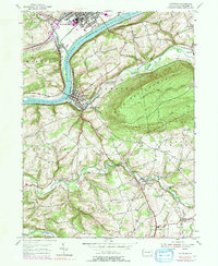
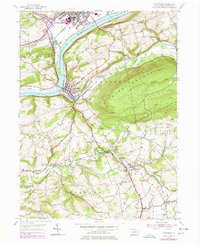
1955 Map of Catawissa
USGS Topo · Published 1991About this map
Catawissa sits at the confluence where Catawissa Creek meets the Susquehanna River, serving as a historic junction for the Conrail lines that trace the riverbank. This mid-century landscape reflects a region defined by its valley milling and upland farming, with small settlements like Parrs Mill and Pensyl Mill established along Roaring Creek. The map documents a deep-rooted community infrastructure, from the Tank Sch and Clayton Sch to numerous country churches like Emanuel Ch and the Old Quaker Ch.
Find a feature on this map
57 named features on this map. Tap any name to fly to it.
Don’t see what you’re looking for? This feature index may not catch every label — zoom into the map to look around manually.
Map Details
Editions of this 1955 Catawissa Map
5 editions found
Other maps of this area

1889 · Catawissa
USGS Topo · 1:62,500

1892 · Catawissa
USGS Topo · 1:62,500

1892 · Shamokin
USGS Topo · 1:62,500

1893 · Shamokin
USGS Topo · 1:62,500

1894 · Catawissa
USGS Topo · 1:62,500

1894 · Bloomsburg
USGS Topo · 1:62,500

1935 · Hughesville
USGS Topo · 1:62,500

1943 · Shamokin
USGS Topo · 1:62,500

1947 · Bloomsburg
USGS Topo · 1:24,000

1947 · Ashland
USGS Topo · 1:24,000