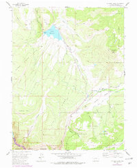
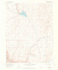
1957 Map of Cathedral Peak
USGS Topo · Published 1979About this map
Gould Reservoir and its surrounding waterworks dominate the high country of this mid-century landscape. The map details an intricate system of irrigation including the Fruitland Ditch, Cattlemans Ditch, and Dyer Fork Ditch, reflecting the critical importance of water management on Fruitland Mesa. While the Gunnison River carves through the southwestern corner within the Curecanti National Recreation Area, the interior is defined by sharp topographic shifts from Poison Spring Ridge to the depths of Iron Creek Canyon. Settlement is sparse, with Gates Camp marking a rare named outpost amidst the expansive reaches of the Gunnison National Forest. This document traces the intersection of rugged public lands and the agricultural infrastructure necessary to sustain the neighboring plateaus.
Find a feature on this map
32 named features on this map. Tap any name to fly to it.
Don’t see what you’re looking for? This feature index may not catch every label — zoom into the map to look around manually.
Map Details
Editions of this 1957 Cathedral Peak Map
7 editions found
Other maps of this area

1908 · Uncompahgre
USGS Topo · 1:125,000

1909 · Montrose
USGS Topo · 1:125,000

1911 · Uncompahgre
USGS Topo · 1:125,000

1911 · Montrose
USGS Topo · 1:125,000

1956 · Curecanti Needle
USGS Topo · 1:24,000

1956 · Cimarron
USGS Topo · 1:24,000

1956 · Montrose
USGS Topo · 1:250,000

1957 · Cathedral Peak
USGS Topo · 1:24,000

1957 · X Lazy F Ranch
USGS Topo · 1:24,000

1957 · Cerro Summit
USGS Topo · 1:24,000