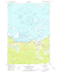
1949 Map of Cathlamet Bay
USGS Topo · Published 1977About this map
Columbia River maritime life and riverine commerce define this 1949 landscape near the mouth of the great waterway. The map documents a complex network of shifting sandbars, channels, and islands, including the sprawling Woody Island and the smaller McGregor Island, which navigate the space between the main Point Channel and the South Channel. Along the southern shore, the community of Svensen serves as a local hub, supported by the Svensen Sch and positioned at the intersection of the Columbia River Highway and the Burlington Northern railroad lines. The topography transitions sharply from the expansive Tidal Flat areas of Cathlamet Bay to the rising timbered elevations of Fern Hill. This document captures the mid-century infrastructure of the Oregon coast, including navigational aids like Front Range Light and Beacon No 4, alongside local features such as the Landing Strip near Ferris Creek.
Find a feature on this map
38 named features on this map. Tap any name to fly to it.
Don’t see what you’re looking for? This feature index may not catch every label — zoom into the map to look around manually.
Map Details
Editions of this 1949 Cathlamet Bay Map
4 editions found
Other maps of this area

1919 · Astoria
USGS Topo · 1:62,500

1938 · Fort Columbia
USGS Topo · 1:62,500

1939 · Astoria
USGS Topo · 1:62,500

1940 · Svensen
USGS Topo · 1:62,500

1940 · Brookfield
USGS Topo · 1:62,500

1943 · Fort Columbia
USGS Topo · 1:62,500

1949 · Astoria
USGS Topo · 1:24,000

1949 · Knappton
USGS Topo · 1:24,000

1949 · Cathlamet Bay
USGS Topo · 1:24,000

1949 · Green Mountain
USGS Topo · 1:24,000