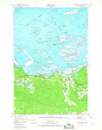
1949 Map of Cathlamet Bay
USGS Topo · Published 1967About this map
The Columbia River dominates this mid-century landscape, carving a complex network of channels and islands east of Astoria. Land management and industrial progress are evident at Mott Island, while the Spokane Portland and Seattle railroad and the Columbia River Highway trace the southern shoreline, facilitating the region's timber and river-based economy. The settlement of Svensen serves as a local hub, supported by the Svensen Sch and the rail connection at Svensen Junction. The geography is defined by tidal flats and shifting sands, such as Miller Sands and Seal Island, illustrating the dynamic nature of Cathlamet Bay before modern dredging and stabilization fully altered these reaches. Upland, the terrain rises toward Fern Hill, where small drainages like Eskeline Creek and Marsh Creek flow north toward the estuary.
Find a feature on this map
31 named features on this map. Tap any name to fly to it.
Don’t see what you’re looking for? This feature index may not catch every label — zoom into the map to look around manually.
Map Details
Editions of this 1949 Cathlamet Bay Map
4 editions found
Other maps of this area

1919 · Astoria
USGS Topo · 1:62,500

1938 · Fort Columbia
USGS Topo · 1:62,500

1939 · Astoria
USGS Topo · 1:62,500

1940 · Svensen
USGS Topo · 1:62,500

1940 · Brookfield
USGS Topo · 1:62,500

1943 · Fort Columbia
USGS Topo · 1:62,500

1949 · Astoria
USGS Topo · 1:24,000

1949 · Knappton
USGS Topo · 1:24,000

1949 · Cathlamet Bay
USGS Topo · 1:24,000

1949 · Green Mountain
USGS Topo · 1:24,000