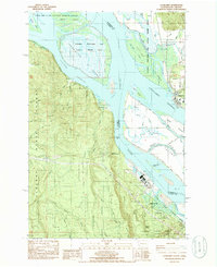
1985 Map of Cathlamet
USGS Topo · Published 1986About this map
Cathlamet sits along the northern bank of the Columbia River, serving as a focal point for the complex network of sloughs and islands that define the border between Washington and Oregon. This mid-1980s survey captures a landscape dominated by conservation and industry, featuring the extensive Columbian White-Tailed Deer National Wildlife Refuge across Tenasillahe Island and the neighboring shoreline. The river’s commercial importance is evidenced by the prominent Paper Mill at Wauna and the Burlington Northern rail line skirting the southern bluffs.
Find a feature on this map
55 named features on this map. Tap any name to fly to it.
Don’t see what you’re looking for? This feature index may not catch every label — zoom into the map to look around manually.
Map Details
Editions of this 1985 Cathlamet Map
This is the sole edition of this map. No revisions or reprints were ever made.
Other maps of this area

1940 · Svensen
USGS Topo · 1:62,500

1940 · Brookfield
USGS Topo · 1:62,500

1941 · Skamokawa
USGS Topo · 1:62,500

1941 · Cathlamet
USGS Topo · 1:62,500

1953 · Hoquiam
USGS Topo · 1:250,000

1953 · Skamokawa
USGS Topo · 1:62,500

1953 · Cathlamet
USGS Topo · 1:62,500
1955 · Svensen
USGS Topo · 1:62,500

1955 · Grays River
USGS Topo · 1:62,500

1957 · Hoquiam
USGS Topo · 1:250,000