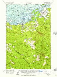
1955 Map of Svensen
USGS Topo · Published 1957About this map
Cathlamet Bay and the Columbia River dominate the northern landscape of this mid-century survey, where the intricate sloughs and islands of the estuary meet the rising timberlands of Clatsop County. The economic life of the 1950s is etched into the terrain through the route of the Spokane Portland and Seattle RR and a network of logging roads and quarries. Small riverfront communities like Svensen, Knappa, and Brownsmead serve as anchors for the local population, supported by institutions such as the Svensen School and Knappa HS. Further inland, the map transitions into the high ridges of Wickiup Mtn and Elk Mountain, where the headwaters of the North Fork Klaskanine River and South Fork Klaskanine River begin their descent toward the coast. Natural resource management is evident through the presence of the Klaskanine Fish Hatchery and the Knappa Guard Sta.
Find a feature on this map
75 named features on this map. Tap any name to fly to it.
Don’t see what you’re looking for? This feature index may not catch every label — zoom into the map to look around manually.
Map Details
Editions of this 1955 Svensen Map
3 editions found
Other maps of this area

1919 · Astoria
USGS Topo · 1:62,500

1938 · Fort Columbia
USGS Topo · 1:62,500

1939 · Astoria
USGS Topo · 1:62,500

1939 · Saddle Mountain
USGS Topo · 1:62,500

1940 · Svensen
USGS Topo · 1:62,500

1940 · Brookfield
USGS Topo · 1:62,500

1940 · Cape Falcon
USGS Topo · 1:62,500

1941 · Keasey
USGS Topo · 1:62,500

1941 · Skamokawa
USGS Topo · 1:62,500

1941 · Cathlamet
USGS Topo · 1:62,500