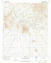
1965 Map of Cave Creek
USGS Topo · Published 1967About this map
The growing desert community of Cave Creek and the planned development of Carefree dominate this mid-1960s survey of the Sonoran landscape. At this time, the transition from old mining claims to modern leisure is visible as the Desert Forest Golf Course and Carefree Airfield sit just miles from historic operations like the Mormon Girl Mine and Phoenix Mine. The rugged topography of Black Mtn and Go John Mtn provides a stark backdrop to the residential expansion moving north from Scottsdale Road. Local history is anchored by the Cave Creek Cemetery and numerous named water sources essential for desert living, including Willow Springs and Grapevine Spring. Further east, the boundary of the Tonto National Forest marks the limit of private development against protected lands, while old Ruins and scattered Jeep Trail paths suggest a long history of exploration throughout the canyons.
Find a feature on this map
28 named features on this map. Tap any name to fly to it.
Don’t see what you’re looking for? This feature index may not catch every label — zoom into the map to look around manually.
Map Details
Editions of this 1965 Cave Creek Map
3 editions found
Other maps of this area

1904 · Camelback
USGS Topo · 1:62,500

1906 · Camelsback
USGS Topo · 1:62,500

1930 · Cave Creek
USGS Topo · 1:125,000

1939 · Cave Creek
USGS Topo · 1:125,000

1954 · Phoenix
USGS Topo · 1:250,000

1954 · Mesa
USGS Topo · 1:250,000

1957 · Mesa
USGS Topo · 1:250,000

1957 · Phoenix
USGS Topo · 1:250,000

1958 · Mesa
USGS Topo · 1:250,000

1958 · Phoenix
USGS Topo · 1:250,000