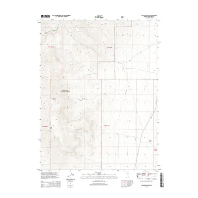
2014 Map of Cave Mountain
USGS Topo · Published 2014About this map
The Schell Creek Range dominates this portion of the Humboldt National Forest, rising sharply from the flats of Spring Valley to the prominent peak of Cave Mtn. This high-desert landscape is defined by its critical water sources, with drainages like Cleve Cr and Bastian Cr cutting through the montane terrain. Local history and land use are reflected in the network of Forest Service infrastructure, including Natl Forest Develop Road 571 Rd and Cleve Creek Rd.
Find a feature on this map
24 named features on this map. Tap any name to fly to it.
Don’t see what you’re looking for? This feature index may not catch every label — zoom into the map to look around manually.
Map Details
Editions of this 2014 Cave Mountain Map
This is the sole edition of this map. No revisions or reprints were ever made.
Other maps of this area

1952 · Ely
USGS Topo · 1:125,000

1956 · Ely
USGS Topo · 1:250,000

1959 · Ely
USGS Topo · 1:250,000

1959 · Sacramento Pass
USGS Topo · 1:62,500

1959 · Connors Pass
USGS Topo · 1:62,500

1959 · Schell Peaks
USGS Topo · 1:62,500

1963 · Ely
USGS Topo · 1:250,000
1981 · Connors Pass
USGS Topo · 1:24,000
1981 · Majors Place
USGS Topo · 1:24,000
1981 · South Schell Peak
USGS Topo · 1:24,000