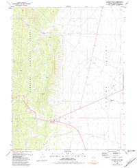
1981 Map of Majors Place
USGS Topo · Published 1981About this map
Majors Place serves as the focal point of this high-desert landscape where highway routes intersect at the southern edge of Spring Valley. The terrain is defined by the sharp transition between the alluvial flats and the eastern slopes of the Humboldt National Forest, where Cooper Canyon cuts through the steep ridges. Evidence of human activity and resource extraction is scattered across the map, from the Ruins located north of the primary crossroads to the Gravel Pits and Borrow Pit operations that support regional infrastructure.
Find a feature on this map
12 named features on this map. Tap any name to fly to it.
Don’t see what you’re looking for? This feature index may not catch every label — zoom into the map to look around manually.
Map Details
Editions of this 1981 Majors Place Map
3 editions found
Other maps of this area

1948 · Wheeler Peak
USGS Topo · 1:62,500

1950 · Wheeler Peak
USGS Topo · 1:62,500

1952 · Ely
USGS Topo · 1:125,000

1956 · Lund
USGS Topo · 1:250,000

1956 · Ely
USGS Topo · 1:250,000

1959 · Ely
USGS Topo · 1:250,000

1959 · Sacramento Pass
USGS Topo · 1:62,500

1959 · Connors Pass
USGS Topo · 1:62,500

1960 · Lund
USGS Topo · 1:250,000

1963 · Ely
USGS Topo · 1:250,000