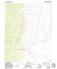
1981 Map of Majors Place
USGS Topo · Published 1994About this map
Majors Place serves as the primary landmark in this Great Basin landscape, situated at the junction of transportation routes between the high peaks and the broad expanse of Spring Valley. To the west, the steep slopes of the Humboldt National Forest are carved by drainage systems like Cooper Canyon, where Allen Spring provides a rare water source in the arid environment. Evidence of human activity and habitation is scattered throughout the region, including unnamed Ruins and early mining attempts at Prospects Rattlesnake Knoll. The terrain reflects a mix of conservation and extraction, with multiple Gravel Pits and a Borrow Pit indicating local industrial material needs. This 1981 survey, updated in the early 1990s, documents the ranching and resource-based infrastructure of White Pine County during a period of relative isolation before more modern developments reached this part of Nevada.
Find a feature on this map
12 named features on this map. Tap any name to fly to it.
Don’t see what you’re looking for? This feature index may not catch every label — zoom into the map to look around manually.
Map Details
Editions of this 1981 Majors Place Map
3 editions found
Other maps of this area

1948 · Wheeler Peak
USGS Topo · 1:62,500

1950 · Wheeler Peak
USGS Topo · 1:62,500

1952 · Ely
USGS Topo · 1:125,000

1956 · Lund
USGS Topo · 1:250,000

1956 · Ely
USGS Topo · 1:250,000

1959 · Ely
USGS Topo · 1:250,000

1959 · Sacramento Pass
USGS Topo · 1:62,500

1959 · Connors Pass
USGS Topo · 1:62,500

1960 · Lund
USGS Topo · 1:250,000

1963 · Ely
USGS Topo · 1:250,000