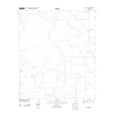
2012 Map of Cave Spring
USGS Topo · Published 2012About this map
Cave Spring sits at the heart of this West Texas landscape, where seasonal watercourses and local landmarks define the rural geography of Tom Green County. The terrain is characterized by the meandering path of the S Concho River and its associated South Concho Draw, alongside isolated water features like the Panther Bluff Waterhole. This 2012 survey illustrates a network of ranch and county roads, including the evocatively named Toenail Trl and Stansbury Road Private. The prevalence of labels such as Dry Cr underscores the importance of every reliable water source in this arid environment. This documentation captures the modern configuration of family-named lanes like Harkey Ln and Jones Rd, providing a clear record of land access and drainage patterns in this sparsely settled region of the Edwards Plateau.
Find a feature on this map
13 named features on this map. Tap any name to fly to it.
Don’t see what you’re looking for? This feature index may not catch every label — zoom into the map to look around manually.
Map Details
Editions of this 2012 Cave Spring Map
This is the sole edition of this map. No revisions or reprints were ever made.
Other maps of this area

1892 · San Angelo
USGS Topo · 1:125,000

1893 · Fort McKavett
USGS Topo · 1:125,000

1895 · Sherwood
USGS Topo · 1:125,000

1954 · Sonora
USGS Topo · 1:250,000

1954 · San Angelo
USGS Topo · 1:250,000

1958 · Sonora
USGS Topo · 1:250,000

1958 · San Angelo
USGS Topo · 1:250,000

1963 · Adams
USGS Topo · 1:24,000

1963 · Adams NW
USGS Topo · 1:24,000
1964 · Eldorado NE
USGS Topo · 1:24,000