
1963 Map of Adams NW
USGS Topo · Published 1966About this map
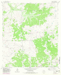
South Concho Draw and Milligan Draw carve through this section of the Edwards Plateau, defining a landscape dominated by large-scale ranching operations in the early 1960s. The map serves as a detailed record of land ownership and agricultural infrastructure, identifying several family-named properties including White Ranch, Brown Ranch, and the Lovelace Ranch. These holdings are connected by a network of unimproved roads and light-duty trails, with fine red dashed lines indicating selected fence lines that reveal the partitioning of the Texas backcountry. While primarily pastoral, the presence of an Oil Well and numerous Gravel Pit locations indicates the early diversification of the local economy beyond livestock. Water management is central to life here, evidenced by various labeled Wells and the natural drainage patterns of Live Oak Hollow and North Valley.
Find a feature on this map
18 named features on this map. Tap any name to fly to it.
Don’t see what you’re looking for? This feature index may not catch every label — zoom into the map to look around manually.
Map Details
Editions of this 1963 Adams NW Map
2 editions found
Other maps of this area

1892 · San Angelo
USGS Topo · 1:125,000

1893 · Fort McKavett
USGS Topo · 1:125,000

1895 · Sherwood
USGS Topo · 1:125,000

1954 · Sonora
USGS Topo · 1:250,000

1954 · San Angelo
USGS Topo · 1:250,000

1958 · Sonora
USGS Topo · 1:250,000

1958 · San Angelo
USGS Topo · 1:250,000

1963 · Adams
USGS Topo · 1:24,000

1963 · Adams SE
USGS Topo · 1:24,000

1963 · Adams SW
USGS Topo · 1:24,000