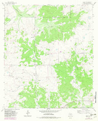
1963 Map of Adams NW
USGS Topo · Published 1982About this map
Scattered cattle and sheep operations define the high-plateau character of this West Texas landscape during the early 1960s. The region is marked by a network of family-owned ranching estates, including White Ranch, Brown Ranch, and Robinson Ranch, which are situated along the intermittent drainages of the Edwards Plateau. Natural water management is dictated by the rugged topography of South Concho Draw and Milligan Draw, where seasonal runoff eventually feeds larger systems. The map captures an era of infrastructure development in Schleicher County, evidenced by a prominent Pipeline and several industrial Pit and Gravel Pit locations. These features, alongside the Ewing Ranch and Burrus Ranch, suggest a balance between traditional pastoral life and the expanding energy and material extraction industries of the mid-twentieth century. Further south, the terrain descends toward North Valley and Live Oak Hollow, illustrating the typical arroyo and draw systems of the Concho River watershed.
Find a feature on this map
17 named features on this map. Tap any name to fly to it.
Don’t see what you’re looking for? This feature index may not catch every label — zoom into the map to look around manually.
Map Details
Editions of this 1963 Adams NW Map
2 editions found
Other maps of this area

1892 · San Angelo
USGS Topo · 1:125,000

1893 · Fort McKavett
USGS Topo · 1:125,000

1895 · Sherwood
USGS Topo · 1:125,000

1954 · Sonora
USGS Topo · 1:250,000

1954 · San Angelo
USGS Topo · 1:250,000

1958 · Sonora
USGS Topo · 1:250,000

1958 · San Angelo
USGS Topo · 1:250,000

1963 · Adams
USGS Topo · 1:24,000

1963 · Adams NW
USGS Topo · 1:24,000

1963 · Adams SE
USGS Topo · 1:24,000