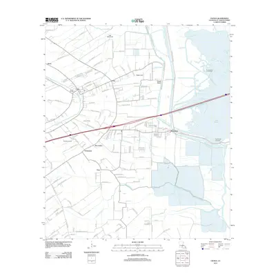
2012 Map of Cecilia
USGS Topo · Published 2012About this map
Bayou Teche winds through this section of Saint Martin Parish, serving as the historical spine for settlements like Cecilia and Henderson. The landscape is a complex network of managed waterways, including the Little Platte Canal, Dumolin Canal, and Dupuis Canal, reflecting a long history of drainage and irrigation required for the region's agricultural and industrial pursuits. The presence of the Cecilia Oil Field and the Plumb Bob Oil and Gas Field indicates the significant role of mineral extraction in the local economy during the early 21st century.
Find a feature on this map
154 named features on this map. Tap any name to fly to it.
Don’t see what you’re looking for? This feature index may not catch every label — zoom into the map to look around manually.
Map Details
Editions of this 2012 Cecilia Map
This is the sole edition of this map. No revisions or reprints were ever made.
Other maps of this area

1935 · Osca Bayou
USGS Topo · 1:62,500

1939 · St. Martinsville
USGS Topo · 1:62,500

1940 · Arnaudville
USGS Topo · 1:62,500

1941 · Loreauville
USGS Topo · 1:62,500

1954 · Loreauville
USGS Topo · 1:62,500

1954 · Baton Rouge
USGS Topo · 1:250,000

1955 · Osca Bayou
USGS Topo · 1:62,500

1956 · Baton Rouge
USGS Topo · 1:250,000

1957 · St. Martinville
USGS Topo · 1:62,500
1959 · Osca Bayou
USGS Topo · 1:62,500