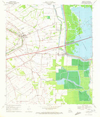
1970 Map of Cecilia
USGS Topo · Published 1972About this map
Bayou Teche defines the western agricultural corridor of this St. Martin Parish landscape, where the settlement of Cecilia serves as a local hub for the Missouri Pacific railroad. The map illustrates a transitional economy between the traditional riverside settlements like Champagne and Nina Station and the emerging industrial presence of the Cecilia Oil Field. East of the protective Levee, the environment shifts abruptly into the swampy expanse of the Atchafalaya Basin Floodway, where the Plumb Bob Oil and Gas Field and numerous Crawfish Farms mark the specialized land use of the Louisiana basin. The presence of Our Lady of Mercy Cem and Teche Sch provides essential coordinates for those researching the social fabric of these Acadian communities during the early 1970s.
Find a feature on this map
38 named features on this map. Tap any name to fly to it.
Don’t see what you’re looking for? This feature index may not catch every label — zoom into the map to look around manually.
Map Details
Editions of this 1970 Cecilia Map
This is the sole edition of this map. No revisions or reprints were ever made.
Other maps of this area

1935 · Osca Bayou
USGS Topo · 1:62,500

1939 · St. Martinsville
USGS Topo · 1:62,500

1940 · Arnaudville
USGS Topo · 1:62,500

1941 · Loreauville
USGS Topo · 1:62,500

1954 · Loreauville
USGS Topo · 1:62,500

1954 · Baton Rouge
USGS Topo · 1:250,000

1955 · Osca Bayou
USGS Topo · 1:62,500

1956 · Baton Rouge
USGS Topo · 1:250,000

1957 · St. Martinville
USGS Topo · 1:62,500
1959 · Osca Bayou
USGS Topo · 1:62,500