
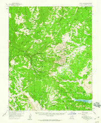
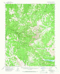
1958 Map of Cedar Breaks
USGS Topo · Published 1983About this map
Cedar Breaks National Monument and the surrounding high-elevation plateaus of Dixie National Forest define this mid-century landscape in Iron County. The topographic survey reveals a rugged geography shaped by volcanic activity, noted by the presence of Lava fields and prominent summits such as Brian Head and Sidney Peaks. While much of the terrain is dedicated to conservation, the map preserves the location of earlier industrial and residential footprints, including the Cluff Mine and MacFarlane Mine near Ashdown Creek, and the seasonal habitation at Wood Ranch.
Find a feature on this map
147 named features on this map. Tap any name to fly to it.
Don’t see what you’re looking for? This feature index may not catch every label — zoom into the map to look around manually.
Map Details
Editions of this 1958 Cedar Breaks Map
3 editions found
Historical Maps of Brian Head Through Time
292 maps found

1949 Cedar City NW
Iron County, UT

1950 Antelope Peak
Iron County, UT

1950 Avon SE
Iron County, UT

1950 Cedar City NW
Iron County, UT

1950 Cedar Mountain
Iron County, UT

1950 Desert Mound
Iron County, UT

1950 Enoch NE
Iron County, UT

1950 Iron Mountain
Iron County, UT

1950 Page Ranch
Iron County, UT

1950 Silver Peak
Iron County, UT

1950 Stoddard Mtn
Iron County, UT

1950 The Three Peaks
Iron County, UT

1951 Avon
Iron County, UT

1951 Avon NW
Iron County, UT

1951 Avon SE
Iron County, UT

1951 Desert Mound
Iron County, UT

1951 Page Ranch
Iron County, UT

1951 Silver Peak
Iron County, UT

1951 Stoddard Mtn
Iron County, UT

1951 The Three Peaks
Iron County, UT

1952 Cedar Mountain
Iron County, UT

1952 Enoch NE
Iron County, UT

1952 Enoch NW
Iron County, UT
1958 Cedar Breaks
Iron County, UT

1958 Thermo
Iron County, UT

1971 Bible Spring
Iron County, UT

1971 Buckhorn Flat
Iron County, UT

1971 Burnt Peak
Iron County, UT

1971 Cottonwood Mtn
Iron County, UT

1971 Latimer
Iron County, UT

1971 Little Creek Peak
Iron County, UT

1971 Lund
Iron County, UT

1971 Parowan Gap
Iron County, UT

1971 Red Creek Reservoir
Iron County, UT

1971 Steamboat Mtn
Iron County, UT

1971 Steamboat Mtn SW
Iron County, UT

1972 Bannion Spring
Iron County, UT

1972 Beryl
Iron County, UT

1972 Clark Farm
Iron County, UT

1972 Eightmile Spring
Iron County, UT

1972 Heist
Iron County, UT

1972 Mountain Spring Peak
Iron County, UT

1972 Mount Escalante
Iron County, UT

1972 Pinon Point
Iron County, UT

1972 Yale Crossing
Iron County, UT

1972 Zane
Iron County, UT

1985 Flanigan Arch
Iron County, UT

1985 Henrie Knolls
Iron County, UT

1985 Navajo Lake
Iron County, UT

1985 Panguitch Lake
Iron County, UT

1985 Webster Flat
Iron County, UT

1986 Jack Henry Knoll
Iron County, UT

1989 Baboon Peak
Iron County, UT

1989 Badger Peak
Iron County, UT

1989 Dry Willow Peak
Iron County, UT

2002 Cottonwood Mountain
Iron County, UT

2002 Flanigan Arch
Iron County, UT

2002 Henrie Knolls
Iron County, UT

2002 Little Creek Peak
Iron County, UT

2002 Mount Escalante
Iron County, UT

2002 Navajo Lake
Iron County, UT

2002 Page Ranch
Iron County, UT

2002 Panguitch Lake
Iron County, UT

2002 Pinon Point
Iron County, UT

2002 Red Creek Reservoir
Iron County, UT

2002 Uvada
Iron County, UT

2002 Webster Flat
Iron County, UT

2010 Baboon Peak
Iron County, UT

2010 Badger Peak
Iron County, UT

2010 Bible Spring
Iron County, UT

2010 Buckhorn Flat
Iron County, UT

2010 Burnt Peak
Iron County, UT

2010 Dry Willow Peak
Iron County, UT

2010 Jack Henry Knoll
Iron County, UT

2010 Latimer
Iron County, UT

2010 Lund
Iron County, UT

2010 Mountain Spring Peak
Iron County, UT

2010 Steamboat Mountain
Iron County, UT

2010 Steamboat Mountain SW
Iron County, UT

2011 Antelope Peak
Iron County, UT

2011 Avon
Iron County, UT

2011 Avon NW
Iron County, UT

2011 Avon SE
Iron County, UT

2011 Bannion Spring
Iron County, UT

2011 Beryl
Iron County, UT

2011 Cedar City NW
Iron County, UT

2011 Cedar Mountain
Iron County, UT

2011 Clark Farm
Iron County, UT

2011 Cottonwood Mountain
Iron County, UT

2011 Desert Mound
Iron County, UT

2011 Eightmile Spring
Iron County, UT

2011 Enoch NE
Iron County, UT

2011 Enoch NW
Iron County, UT

2011 Flanigan Arch
Iron County, UT

2011 Heist
Iron County, UT

2011 Henrie Knolls
Iron County, UT

2011 Little Creek Peak
Iron County, UT

2011 Mount Escalante
Iron County, UT

2011 Navajo Lake
Iron County, UT

2011 Page Ranch
Iron County, UT

2011 Panguitch Lake
Iron County, UT

2011 Parowan Gap
Iron County, UT

2011 Pinon Point
Iron County, UT

2011 Red Creek Reservoir
Iron County, UT

2011 Rice Mountain
Iron County, UT

2011 Silver Peak
Iron County, UT

2011 Stoddard Mountain
Iron County, UT

2011 The Three Peaks
Iron County, UT

2011 Uvada
Iron County, UT

2011 Webster Flat
Iron County, UT

2011 Yale Crossing
Iron County, UT

2011 Zane
Iron County, UT

2014 Antelope Peak
Iron County, UT

2014 Avon
Iron County, UT

2014 Avon NW
Iron County, UT

2014 Avon SE
Iron County, UT

2014 Baboon Peak
Iron County, UT

2014 Badger Peak
Iron County, UT

2014 Bannion Spring
Iron County, UT

2014 Beryl
Iron County, UT

2014 Bible Spring
Iron County, UT

2014 Buckhorn Flat
Iron County, UT

2014 Burnt Peak
Iron County, UT

2014 Cedar City NW
Iron County, UT

2014 Cedar Mountain
Iron County, UT

2014 Clark Farm
Iron County, UT

2014 Cottonwood Mountain
Iron County, UT

2014 Desert Mound
Iron County, UT

2014 Dry Willow Peak
Iron County, UT

2014 Eightmile Spring
Iron County, UT

2014 Enoch NE
Iron County, UT

2014 Enoch NW
Iron County, UT

2014 Flanigan Arch
Iron County, UT

2014 Heist
Iron County, UT

2014 Henrie Knolls
Iron County, UT

2014 Jack Henry Knoll
Iron County, UT

2014 Latimer
Iron County, UT

2014 Little Creek Peak
Iron County, UT

2014 Lund
Iron County, UT

2014 Mountain Spring Peak
Iron County, UT

2014 Mount Escalante
Iron County, UT

2014 Navajo Lake
Iron County, UT

2014 Page Ranch
Iron County, UT

2014 Panguitch Lake
Iron County, UT

2014 Parowan Gap
Iron County, UT

2014 Pinon Point
Iron County, UT

2014 Red Creek Reservoir
Iron County, UT

2014 Rice Mountain
Iron County, UT

2014 Silver Peak
Iron County, UT

2014 Steamboat Mountain
Iron County, UT

2014 Steamboat Mountain SW
Iron County, UT

2014 Stoddard Mountain
Iron County, UT

2014 The Three Peaks
Iron County, UT

2014 Uvada
Iron County, UT

2014 Webster Flat
Iron County, UT

2014 Yale Crossing
Iron County, UT

2014 Zane
Iron County, UT

2017 Antelope Peak
Iron County, UT

2017 Avon
Iron County, UT

2017 Avon NW
Iron County, UT

2017 Avon SE
Iron County, UT

2017 Baboon Peak
Iron County, UT

2017 Badger Peak
Iron County, UT

2017 Bannion Spring
Iron County, UT

2017 Beryl
Iron County, UT

2017 Bible Spring
Iron County, UT

2017 Buckhorn Flat
Iron County, UT

2017 Burnt Peak
Iron County, UT

2017 Cedar City NW
Iron County, UT

2017 Cedar Mountain
Iron County, UT

2017 Clark Farm
Iron County, UT

2017 Cottonwood Mountain
Iron County, UT

2017 Desert Mound
Iron County, UT

2017 Dry Willow Peak
Iron County, UT

2017 Eightmile Spring
Iron County, UT

2017 Enoch NE
Iron County, UT

2017 Enoch NW
Iron County, UT

2017 Flanigan Arch
Iron County, UT

2017 Heist
Iron County, UT

2017 Henrie Knolls
Iron County, UT

2017 Jack Henry Knoll
Iron County, UT

2017 Latimer
Iron County, UT

2017 Little Creek Peak
Iron County, UT

2017 Lund
Iron County, UT

2017 Mountain Spring Peak
Iron County, UT

2017 Mount Escalante
Iron County, UT

2017 Navajo Lake
Iron County, UT

2017 Page Ranch
Iron County, UT

2017 Panguitch Lake
Iron County, UT

2017 Parowan Gap
Iron County, UT

2017 Pinon Point
Iron County, UT

2017 Red Creek Reservoir
Iron County, UT

2017 Rice Mountain
Iron County, UT

2017 Silver Peak
Iron County, UT

2017 Steamboat Mountain
Iron County, UT

2017 Steamboat Mountain SW
Iron County, UT

2017 Stoddard Mountain
Iron County, UT

2017 The Three Peaks
Iron County, UT

2017 Uvada
Iron County, UT

2017 Webster Flat
Iron County, UT

2017 Yale Crossing
Iron County, UT

2017 Zane
Iron County, UT

2020 Antelope Peak
Iron County, UT

2020 Avon
Iron County, UT

2020 Avon NW
Iron County, UT

2020 Avon SE
Iron County, UT

2020 Baboon Peak
Iron County, UT

2020 Badger Peak
Iron County, UT

2020 Bannion Spring
Iron County, UT

2020 Beryl
Iron County, UT

2020 Bible Spring
Iron County, UT

2020 Buckhorn Flat
Iron County, UT

2020 Burnt Peak
Iron County, UT

2020 Cedar City NW
Iron County, UT

2020 Cedar Mountain
Iron County, UT

2020 Clark Farm
Iron County, UT

2020 Cottonwood Mountain
Iron County, UT

2020 Desert Mound
Iron County, UT

2020 Dry Willow Peak
Iron County, UT

2020 Eightmile Spring
Iron County, UT

2020 Enoch NE
Iron County, UT

2020 Enoch NW
Iron County, UT

2020 Flanigan Arch
Iron County, UT

2020 Heist
Iron County, UT

2020 Henrie Knolls
Iron County, UT

2020 Jack Henry Knoll
Iron County, UT

2020 Latimer
Iron County, UT

2020 Little Creek Peak
Iron County, UT

2020 Lund
Iron County, UT

2020 Mountain Spring Peak
Iron County, UT

2020 Mount Escalante
Iron County, UT

2020 Navajo Lake
Iron County, UT

2020 Page Ranch
Iron County, UT

2020 Panguitch Lake
Iron County, UT

2020 Parowan Gap
Iron County, UT

2020 Pinon Point
Iron County, UT

2020 Red Creek Reservoir
Iron County, UT

2020 Rice Mountain
Iron County, UT

2020 Silver Peak
Iron County, UT

2020 Steamboat Mountain
Iron County, UT

2020 Steamboat Mountain SW
Iron County, UT

2020 Stoddard Mountain
Iron County, UT

2020 The Three Peaks
Iron County, UT

2020 Uvada
Iron County, UT

2020 Webster Flat
Iron County, UT

2020 Yale Crossing
Iron County, UT

2020 Zane
Iron County, UT

2023 Antelope Peak
Iron County, UT

2023 Avon
Iron County, UT

2023 Avon NW
Iron County, UT

2023 Avon SE
Iron County, UT

2023 Baboon Peak
Iron County, UT

2023 Badger Peak
Iron County, UT

2023 Bannion Spring
Iron County, UT

2023 Beryl
Iron County, UT

2023 Bible Spring
Iron County, UT

2023 Buckhorn Flat
Iron County, UT

2023 Burnt Peak
Iron County, UT

2023 Cedar City NW
Iron County, UT

2023 Cedar Mountain
Iron County, UT

2023 Clark Farm
Iron County, UT

2023 Cottonwood Mountain
Iron County, UT

2023 Desert Mound
Iron County, UT

2023 Dry Willow Peak
Iron County, UT

2023 Eightmile Spring
Iron County, UT

2023 Enoch NE
Iron County, UT

2023 Enoch NW
Iron County, UT

2023 Flanigan Arch
Iron County, UT

2023 Heist
Iron County, UT

2023 Henrie Knolls
Iron County, UT

2023 Jack Henry Knoll
Iron County, UT

2023 Latimer
Iron County, UT

2023 Little Creek Peak
Iron County, UT

2023 Lund
Iron County, UT

2023 Mountain Spring Peak
Iron County, UT

2023 Mount Escalante
Iron County, UT

2023 Navajo Lake
Iron County, UT

2023 Page Ranch
Iron County, UT

2023 Panguitch Lake
Iron County, UT

2023 Parowan Gap
Iron County, UT

2023 Pinon Point
Iron County, UT

2023 Red Creek Reservoir
Iron County, UT

2023 Rice Mountain
Iron County, UT

2023 Silver Peak
Iron County, UT

2023 Steamboat Mountain
Iron County, UT

2023 Steamboat Mountain SW
Iron County, UT

2023 Stoddard Mountain
Iron County, UT

2023 The Three Peaks
Iron County, UT

2023 Uvada
Iron County, UT

2023 Webster Flat
Iron County, UT

2023 Yale Crossing
Iron County, UT

2023 Zane
Iron County, UT