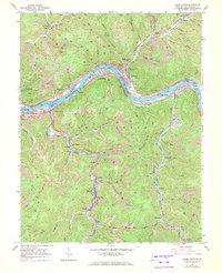
1965 Map of Cedar Grove
USGS Topo · Published 1972About this map
The Kanawha River serves as the central artery for this industrial valley, where the coal and rail infrastructure of the mid-1960s is on full display. Dense clusters of activity concentrate at the river's bend, notably in Cedar Grove and East Bank, where multiple tipples and a sewage disposal plant mark the era's technical footprint. The Penn Central and Chesapeake and Ohio railroads parallel the water, facilitating the movement of resources from numerous strip mines that scar the surrounding ridges. Along the winding course of Cabin Creek, smaller settlements like Sharon, Ronda, and Dawes are linked by the Sharon-Dawes Consolidated School. Genealogists will find several burial grounds, including IOOF Cem and Woodland Cem, providing vital clues to the families who populated these narrow valleys and worked the mines.
Find a feature on this map
71 named features on this map. Tap any name to fly to it.
Don’t see what you’re looking for? This feature index may not catch every label — zoom into the map to look around manually.
Map Details
Editions of this 1965 Cedar Grove Map
3 editions found
Other maps of this area

1897 · Kanawha Falls
USGS Topo · 1:125,000

1899 · Charleston
USGS Topo · 1:125,000

1900 · Kanawha Falls
USGS Topo · 1:125,000

1901 · Kanawha Falls
USGS Topo · 1:125,000

1907 · Clendenin
USGS Topo · 1:62,500

1908 · Montgomery
USGS Topo · 1:48,000

1909 · Charleston
USGS Topo · 1:62,500

1909 · Clendenin
USGS Topo · 1:62,500

1909 · Peytona
USGS Topo · 1:48,000

1910 · Montgomery
USGS Topo · 1:62,500