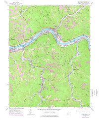
1965 Map of Cedar Grove
USGS Topo · Published 1977About this map
The Kanawha River serves as the industrial spine for these Kanawha County communities, where rail and resource extraction define the landscape. River towns such as East Bank, Cedar Grove, Glasgow, and Pratt are tightly packed between the water and the rising hills, connected by the Conrail and Chesapeake And Ohio railroads. The map documents an intensive carbon economy, with numerous strip mines and tipples situated along the hollows, including significant operations near Ward and Coalburg.
Find a feature on this map
102 named features on this map. Tap any name to fly to it.
Don’t see what you’re looking for? This feature index may not catch every label — zoom into the map to look around manually.
Map Details
Editions of this 1965 Cedar Grove Map
3 editions found
Other maps of this area

1897 · Kanawha Falls
USGS Topo · 1:125,000

1899 · Charleston
USGS Topo · 1:125,000

1900 · Kanawha Falls
USGS Topo · 1:125,000

1901 · Kanawha Falls
USGS Topo · 1:125,000

1907 · Clendenin
USGS Topo · 1:62,500

1908 · Montgomery
USGS Topo · 1:48,000

1909 · Charleston
USGS Topo · 1:62,500

1909 · Clendenin
USGS Topo · 1:62,500

1909 · Peytona
USGS Topo · 1:48,000

1910 · Montgomery
USGS Topo · 1:62,500